Understanding Computer Vision Powered Spatial AI

Key Takeaways
- Spatial Awareness: Spatial AI tracks objects within defined spaces and analyzes their interactions
- Safety Applications: Collision avoidance and hazard detection are primary use cases
- Cross-Industry Impact: From manufacturing to healthcare, spatial AI is transforming operations
- Technical Foundation: Combines depth sensing, neural inference, and semantic segmentation
- Real-Time Analysis: Provides immediate feedback for navigation and safety systems
Beyond Geofencing: The Evolution of Spatial Intelligence
While geofencing—creating virtual boundaries around physical locations—has become familiar through marketing applications, Spatial AI represents a significant evolution of this concept. Rather than simply detecting when an object crosses a boundary, Spatial AI comprehensively analyzes how objects exist, move, and interact within three-dimensional spaces.
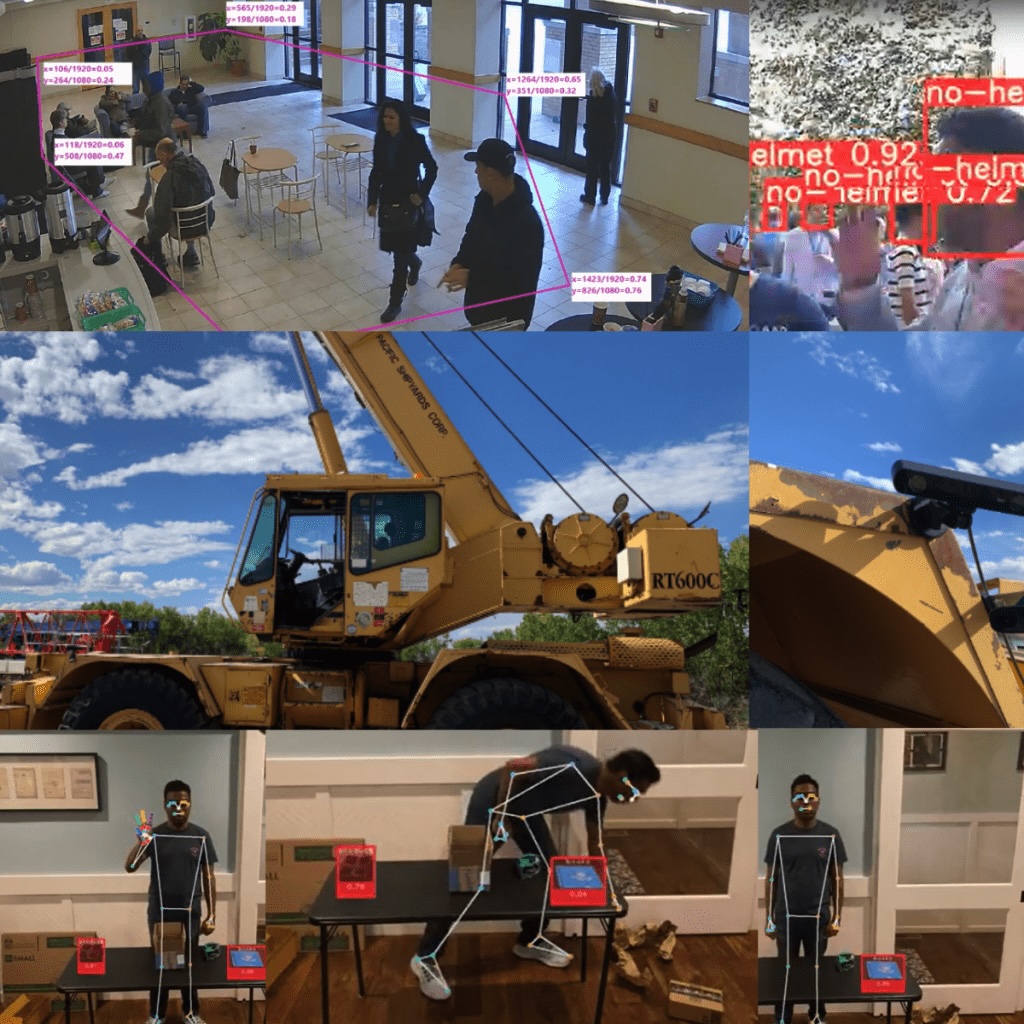 Visualization of depth mapping and object detection in a spatial AI system
This technology combines computer vision with spatial awareness to create systems that understand not just what objects are present, but where they are located, how they're moving, and their relationships to other objects and defined spaces.
What is Spatial AI?
Spatial AI is a specialized branch of computer vision that focuses on tracking, detecting, and quantifying objects within defined spaces. It goes beyond simple object recognition by:
- Mapping three-dimensional environments
- Tracking distances between objects
- Analyzing object movements and trajectories
- Understanding spatial relationships and interactions
- Maintaining awareness of defined boundaries and zones
This spatial understanding enables applications that require precise knowledge of how objects exist and behave in physical space—from autonomous vehicles navigating complex environments to safety systems preventing industrial accidents.
Key Applications Across Industries
Safety and Collision Avoidance
One of the most impactful applications of Spatial AI is in collision avoidance systems:
- Construction Sites: Monitoring crane movements to prevent collisions with buildings, workers, or other equipment
- Autonomous Vehicles: Enabling self-driving cars to detect obstacles and navigate safely
- Industrial Safety: Creating virtual safety zones around dangerous machinery
These systems use depth cameras and sensors to detect when objects enter hazardous areas, triggering automated warnings or preventive actions.
Compliance and Resource Management
Spatial AI helps organizations monitor and optimize their operations:
- Equipment Tracking: Ensuring proper use and location of tools and machinery
- Access Control: Monitoring unauthorized entry into restricted areas
- Resource Deployment: Verifying that personnel are in designated work zones
By maintaining spatial awareness of assets and personnel, organizations can improve efficiency and security while ensuring regulatory compliance.
Advanced Applications
The technology extends into numerous specialized fields:
- Drone Navigation: Creating no-fly zones and enabling obstacle avoidance
- Healthcare: Mapping disease spread through spatial analysis
- Sports and Fitness: Tracking body movements for performance analysis
- Gaming: Enabling spatial interactions in virtual environments
Technical Foundations of Spatial AI
Spatial AI systems rely on several key technologies working in concert:
Neural Inference with Depth Mapping
This approach combines traditional object detection with depth information:
- Neural networks identify objects and landmarks in standard camera frames
- Depth sensors provide distance information for each pixel
- The system fuses these data sources to determine 3D coordinates of detected objects
- Regions of Interest (ROIs) are established with precise spatial boundaries
This creates a comprehensive understanding of what objects exist in the space and exactly where they are located.
Semantic Segmentation
To handle unknown objects, Spatial AI employs semantic segmentation:
- The system identifies and classifies known surfaces (floors, walls, etc.)
- Anything not identified as a surface is considered an object
- This "negative" detection approach allows systems to recognize and avoid obstacles even if they've never encountered them before
This capability is crucial for applications like autonomous navigation, where systems must respond appropriately to novel objects and situations.
Stereo Neural Inference
For systems using stereo vision:
- Landmark detection runs on both left and right camera images
- The system calculates the disparity between corresponding points
- Triangulation with calibrated camera parameters yields precise 3D positions
- This creates accurate spatial mapping without specialized depth sensors
Real-World Impact
The practical applications of Spatial AI are already transforming industries:
- Manufacturing: Reducing accidents by 65% through spatial safety zones
- Autonomous Vehicles: Enabling navigation with 99.9% collision avoidance
- Retail: Optimizing store layouts based on customer movement patterns
- Healthcare: Improving patient monitoring while maintaining privacy
As sensing technology becomes more affordable and processing more efficient, Spatial AI will continue to expand into new applications and industries.
Conclusion
Spatial AI represents a significant advancement in how computer systems understand and interact with the physical world. By combining the object recognition capabilities of computer vision with precise spatial awareness, these systems enable applications that can navigate, monitor, and respond to three-dimensional environments with unprecedented accuracy.
From preventing industrial accidents to enabling autonomous navigation, Spatial AI is creating safer, more efficient operations across industries. As the technology continues to evolve, we can expect even more sophisticated applications that further blur the line between digital intelligence and physical space.
This article provides a historical perspective on Spatial AI technology. While Visionify now specializes in computer vision solutions for various industries, we recognize the continuing importance of spatial awareness in advanced computer vision applications.
Frequently Asked Questions
Find answers to common questions about this topic
Want to learn more?
Discover how our Vision AI safety solutions can transform your workplace safety.
Schedule a DemoSchedule a Meeting
Book a personalized demo with our product specialists to see how our AI safety solutions can work for your business.
Choose a convenient time
Select from available slots in your timezone
30-minute consultation
Brief but comprehensive overview of our solutions
Meet our product experts
Get answers to your specific questions
Related Articles


Subscribe to our newsletter
Get the latest safety insights and updates delivered to your inbox.